McBride Lake fishing map is included in Saskatchewan Fishing Maps nautical charts folio. It is available as part of iBoating : Canada Marine & Fishing App (now supported on multiple platforms including Android, iPhone/iPad, MacBook, and Windows(tablet and phone)/PC based chartplotter. ).
With our Lake Maps App, you get all the great marine chart app features like fishing spots, along with McBride Lake depth map. The fishing maps app include HD lake depth contours, along with advanced features found in Fish Finder / Gps Chart Plotter systems, turning your device into a Depth Finder. The McBride Lake Navigation App provides advanced features of a Marine Chartplotter including adjusting water level offset and custom depth shading. Fishing spots and depth contours layers are available in most Lake maps. Lake navigation features include advanced instrumentation to gather wind speed direction, water temperature, water depth, and accurate GPS with AIS receivers(using NMEA over TCP/UDP). Autopilot support can be enabled during ‘Goto WayPoint’ and ‘Route Assistance’.
Now i-Boating supports Fishing Points in McBride Lake.
Have more questions about the Nautical Chart App? Ask us.
Fishing Info for McBride Lake
McBride Lake is a lake in the east-central part of the Canadian province of Saskatchewan in the boreal forest ecozone of Canada. It is a narrow lake that runs west to east along the course of the Pepaw River known for its fishing and recreational opportunities. It is situated in the Porcupine Hills and within Saskatchewan's Porcupine Provincial Forest. There is a provincial park and a small subdivision along the lake's shore and access is from Highway 983. Eldredge Lake is upstream from McBride Lake along the course of the Pepaw River and Pepaw Lake is downstream. Swallow lake is to the north and a short stream flows from Swallow Lake into the eastern end of McBride Lake. Along the northern shore of the lake is McBride Lake Recreation Site, which is one of five blocks that make up Porcupine Hills Provincial Park. Until 2018, the recreation site was a stand-alone park. At that time McBride Lake and four other recreation sites were merged into one to create Porcupine Hills Provincial Park. The campground in the park has 51 campsites.
More on Wikipedia...Popular fish species in this lake include Northern pike, Walleye and Yellow perch.
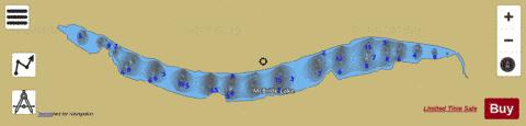
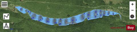
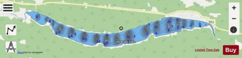
McBride Lake Fishing Map Stats | |
| Title | McBride Lake |
| Scale | 1:12000 |
| Nearby Cities | Hudson Bay, Canora |
| Area * | 663.36 acres |
| Shoreline * | 9.87 miles |
| Min Longitude | -102.46 |
| Min Latitude | 52.45 |
| Max Longitude | -102.36 |
| Max Latitude | 52.46 |
| Edition Label 1 | |
| Edition Label 2 | |
| Edition Label 3 | |
| Id | CA_SK_McBride_Lake_sk |
| Country | CA |
| Projection | Mercator |
| * some Stats may include nearby/connecting waterbodies | |
|