Tempe Town Lake fishing map is available as part of iBoating : USA Marine & Fishing App(now supported on multiple platforms including Android, iPhone/iPad, MacBook, and Windows(tablet and phone)/PC based chartplotter.).
With our Lake Maps App, you get all the great marine chart app features like fishing spots, along with Tempe Town Lake depth map. The fishing maps app include HD lake depth contours, along with advanced features found in Fish Finder / Gps Chart Plotter systems, turning your device into a Depth Finder. The Tempe Town Lake Navigation App provides advanced features of a Marine Chartplotter including adjusting water level offset and custom depth shading. Fishing spots and depth contours layers are available in most Lake maps. Lake navigation features include advanced instrumentation to gather wind speed direction, water temperature, water depth, and accurate GPS with AIS receivers(using NMEA over TCP/UDP). Autopilot support can be enabled during ‘Goto WayPoint’ and ‘Route Assistance’.
Now i-Boating supports Fishing Points in Tempe Town Lake.
Have more questions about the Nautical Chart App? Ask us.
Fishing Info for Tempe Town Lake
Tempe Town Lake is an artificial perennial reservoir located just north of Tempe Butte at the confluence of the intermittent Salt River and the ephemeral Indian Bend Wash in Tempe, Arizona, United States. The reservoir receives much of its water from the Colorado River via the Central Arizona Project. On July 20, 2010, a portion of the west side of the dam that contained the water in the lake collapsed, sending a flood of water into the Salt River and draining the lake.
More on Wikipedia...Popular fish species in this lake include Largemouth bass and Rainbow trout.
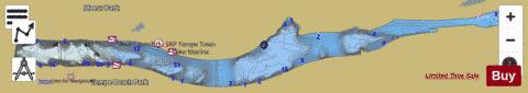


Tempe Town Lake Fishing Map Stats | |
| Title | Tempe Town Lake |
| Sailing Clubs in this Chart region | |
| Arizona Yacht Club | |
| Scale | 1:3000 |
| Counties | Maricopa |
| Nearby Cities | Tempe, Guadalupe, Scottsdale, Mesa, Paradise Valley, Phoenix, Gilbert, Chandler, Higley, Sun Lakes |
| Area * | 312.22 acres |
| Shoreline * | 7.37 miles |
| Min Longitude | -111.95 |
| Min Latitude | 33.43 |
| Max Longitude | -111.89 |
| Max Latitude | 33.44 |
| Edition Label 1 | |
| Edition Label 2 | |
| Edition Label 3 | |
| Id | US_AA_AZ_tempe_town_lake_az |
| Country | US |
| Projection | Mercator |
| * some Stats may include nearby/connecting waterbodies | |
|