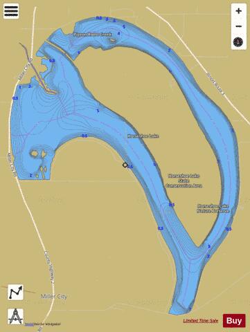
Horseshoe Lake Alexander fishing map is available as part of iBoating : USA Marine & Fishing App(now supported on multiple platforms including Android, iPhone/iPad, MacBook, and Windows(tablet and phone)/PC based chartplotter.).
With our Lake Maps App, you get all the great marine chart app features like fishing spots, along with Horseshoe Lake Alexander depth map. The fishing maps app include HD lake depth contours, along with advanced features found in Fish Finder / Gps Chart Plotter systems, turning your device into a Depth Finder. The Horseshoe Lake Alexander Navigation App provides advanced features of a Marine Chartplotter including adjusting water level offset and custom depth shading. Fishing spots and depth contours layers are available in most Lake maps. Lake navigation features include advanced instrumentation to gather wind speed direction, water temperature, water depth, and accurate GPS with AIS receivers(using NMEA over TCP/UDP). Autopilot support can be enabled during ‘Goto WayPoint’ and ‘Route Assistance’.
Now i-Boating supports Fishing Points in Horseshoe Lake Alexander.
Have more questions about the Nautical Chart App? Ask us.
Fishing Info for Horseshoe Lake Alexander
Horseshoe Lake is an oxbow lake in Alexander County, Illinois. It is the site of Illinois's Horseshoe Lake State Fish and Wildlife Area, a state park 10,645 acres (43 km2) in size. A remnant of a large meander of the Mississippi River, it is today a shallow, isolated patch of water located near Cairo and the southern tip of Illinois. In 1972, the Horseshoe Lake Nature Preserve was designated as a National Natural Landmark by the National Park Service. The Alexander County lake has major problems with siltation. During the Great Flood of 1993 the river tried to shift back to the Horseshoe Lake meander, but returned to its modern channel after the flood subsided. Much of the lake resembles a swamp or bayou. This is one of the northernmost parts of the natural ranges of the Bald cypress and Tupelo trees, which are found on the shoreline of the lake. Another tree found here is the swamp cottonwood. There is a good growth of the flowering American lotus. Other northern stands of Bald Cypress occur in southern Maryland and Delaware. These are some of the most northerly occurrences of the Bald Cypress trees. The site in Maryland, Battle Creek Cypress Swamp, is more than one degree further north. This information does not relate to the Tupelo tree.
More on Wikipedia...Horseshoe Lake Alexander Fishing Map Stats | |
| Title | Horseshoe Lake Alexander |
| Scale | 1:24000 |
| Counties | Alexander |
| Nearby Cities | Olive Branch, Miller City, Commerce, Tamms, Thebes, Mounds, Pulaski, Illmo, Mound City, Elco |
| Area * | 1784.83 acres |
| Shoreline * | 23.31 miles |
| Min Longitude | -89.37 |
| Min Latitude | 37.11 |
| Max Longitude | -89.32 |
| Max Latitude | 37.16 |
| Edition Label 1 | |
| Edition Label 2 | |
| Edition Label 3 | |
| Id | US_AA_IL_horseshoe_lake_alexander_il |
| Country | US |
| Projection | Mercator |
| * some Stats may include nearby/connecting waterbodies | |
|


