Connecticut Lakes fishing map is available as part of iBoating : USA Marine & Fishing App(now supported on multiple platforms including Android, iPhone/iPad, MacBook, and Windows(tablet and phone)/PC based chartplotter.).
With our Lake Maps App, you get all the great marine chart app features like fishing spots, along with Connecticut Lakes lake depth map. The fishing maps app include HD lake depth contours, along with advanced features found in Fish Finder / Gps Chart Plotter systems, turning your device into a Depth Finder. The Connecticut Lakes Navigation App provides advanced features of a Marine Chartplotter including adjusting water level offset and custom depth shading. Fishing spots and depth contours layers are available in most Lake maps. Lake navigation features include advanced instrumentation to gather wind speed direction, water temperature, water depth, and accurate GPS with AIS receivers(using NMEA over TCP/UDP). Autopilot support can be enabled during ‘Goto WayPoint’ and ‘Route Assistance’.
Now i-Boating supports Fishing Points in Connecticut Lakes.
Have more questions about the Nautical Chart App? Ask us.
Fishing Info for Connecticut Lakes
The Connecticut Lakes are a group of lakes in Coos County, northern New Hampshire, United States, situated along the headwaters of the Connecticut River. They are accessed via the northernmost segment of U.S. Route 3, between the village of Pittsburg and the Canada port of entry south of Chartierville, Quebec. The lakes are located within the boundaries of Pittsburg, but are far from the town center. Connecticut Lakes State Forest adjoins them. There are four lakes: First, Second, Third and Fourth Connecticut Lake, numerically running south to north. The lakes decrease in size and increase in elevation, sequentially from first to fourth. The fourth lake is the source of the Connecticut River. The first three lakes can be viewed and accessed from U.S. Route 3, while the only access to the fourth lake is via the Fourth Connecticut Lake Trail, which goes in and out of Canada. All lakes are north of the 45th parallel. Lake Francis lies to the south of the four Connecticut Lakes. It is a man-made reservoir and the last of the major lakes along the Connecticut River in northern New Hampshire.
More on Wikipedia...Popular fish species in this lake include Atlantic salmon, Brook trout, Lake trout and Rainbow trout.
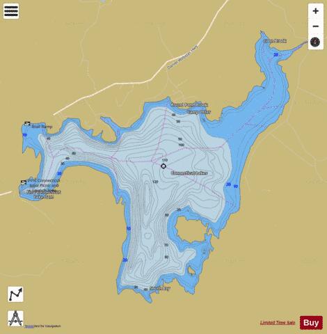
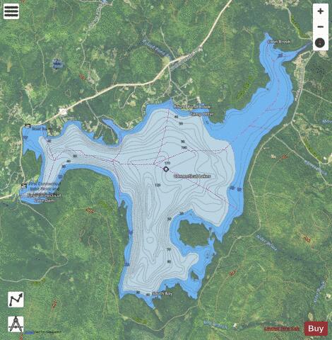
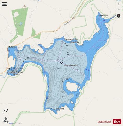
Connecticut Lakes Fishing Map Stats | |
| Title | Connecticut Lakes |
| Scale | 1:6000 |
| Counties | Coos |
| Nearby Cities | Pittsburg, Beecher Falls, Stewartstown, Wilsons Mills, West Stewartstown, Canaan, Colebrook, Errol, Columbia, Upton |
| Area * | 3071.09 acres |
| Shoreline * | 22.61 miles |
| Min Longitude | -71.29 |
| Min Latitude | 45.07 |
| Max Longitude | -71.21 |
| Max Latitude | 45.12 |
| Edition Label 1 | |
| Edition Label 2 | |
| Edition Label 3 | |
| Id | US_NH_01890364 |
| Country | US |
| Projection | Mercator |
| * some Stats may include nearby/connecting waterbodies | |
|