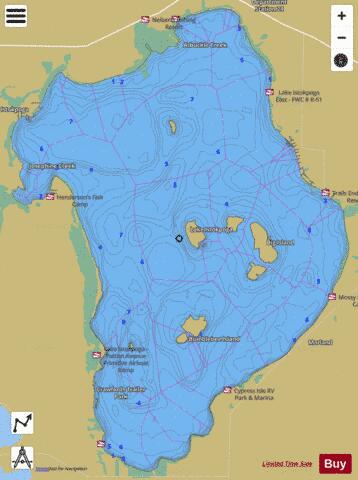
LAKE ISTOKPOGA fishing map is available as part of iBoating : USA Marine & Fishing App(now supported on multiple platforms including Android, iPhone/iPad, MacBook, and Windows(tablet and phone)/PC based chartplotter.).
With our Lake Maps App, you get all the great marine chart app features like fishing spots, along with LAKE ISTOKPOGA depth map. The fishing maps app include HD lake depth contours, along with advanced features found in Fish Finder / Gps Chart Plotter systems, turning your device into a Depth Finder. The LAKE ISTOKPOGA Navigation App provides advanced features of a Marine Chartplotter including adjusting water level offset and custom depth shading. Fishing spots and depth contours layers are available in most Lake maps. Lake navigation features include advanced instrumentation to gather wind speed direction, water temperature, water depth, and accurate GPS with AIS receivers(using NMEA over TCP/UDP). Autopilot support can be enabled during ‘Goto WayPoint’ and ‘Route Assistance’.
Now i-Boating supports Fishing Points in LAKE ISTOKPOGA.
Have more questions about the Nautical Chart App? Ask us.
Fishing Info for LAKE ISTOKPOGA
Lake Istokpoga is a 26,762.9-acre (108.306 km2) freshwater lake in Highlands County, Florida. It is fed by two creeks, Arbuckle Creek and . The oblong-shaped lake is approximately 5 miles (8.0 km) wide by 10 miles (16 km) long. It is considered the fifth largest lake in the state of Florida. Despite its area, it is very shallow, with an average depth of only 4 feet (1.2 m). Maximum depth is 10 feet (3.0 m). As a result, boaters must be cautious to not become stranded in muck near the shore line. Bass and pontoon boats are the most commonly used watercraft, with some use of airboats. With such shallowness, this lake is extremely dangerous for boaters during windstorms, as the waves get quite high. Boating and fishing are popular activities at this lake. There are at least half a dozen fish camps on Lake Istokpoga. Several of these fish camps book visitors for fishing trips and they also have cabins and hook up for campers, for overnight stays. The amenities on the lake are 5 public boat ramps and 2 public parks, one on the lake's north side and the other on the south east corner. Most of the shoreline is undeveloped and there are two islands, Big and Bumble Bee, in the lake's interior. Some residential properties and private boat docks and beaches dot areas on the shore. Local legend is that the word Istokpoga is of the Seminole language meaning "a lake where someone was killed in the water" because a group of Seminole Indians attempted to cross the lake and were bogged in the mire and swallowed by whirlpools. Lake Istokpoga serves as a home for the snail kite.
More on Wikipedia...LAKE ISTOKPOGA Fishing Map Stats | |
| Title | LAKE ISTOKPOGA |
| Scale | 1:12000 |
| 1 ft Depth Contours for Anglers | Yes |
| Counties | Highlands |
| Nearby Cities | Lorida, Plains, Lake Placid, De Soto City, Placid Lakes, Cornwell, Sebring, Fort Basinger, Brighton, Basinger |
| Area * | 26673.06 acres |
| Shoreline * | 54.59 miles |
| Min Longitude | -81.35 |
| Min Latitude | 27.30 |
| Max Longitude | -81.22 |
| Max Latitude | 27.45 |
| Edition Label 1 | |
| Edition Label 2 | |
| Edition Label 3 | |
| Id | US_FL_00284635 |
| Country | US |
| Projection | Mercator |
| * some Stats may include nearby/connecting waterbodies | |
|


